
Management Framework
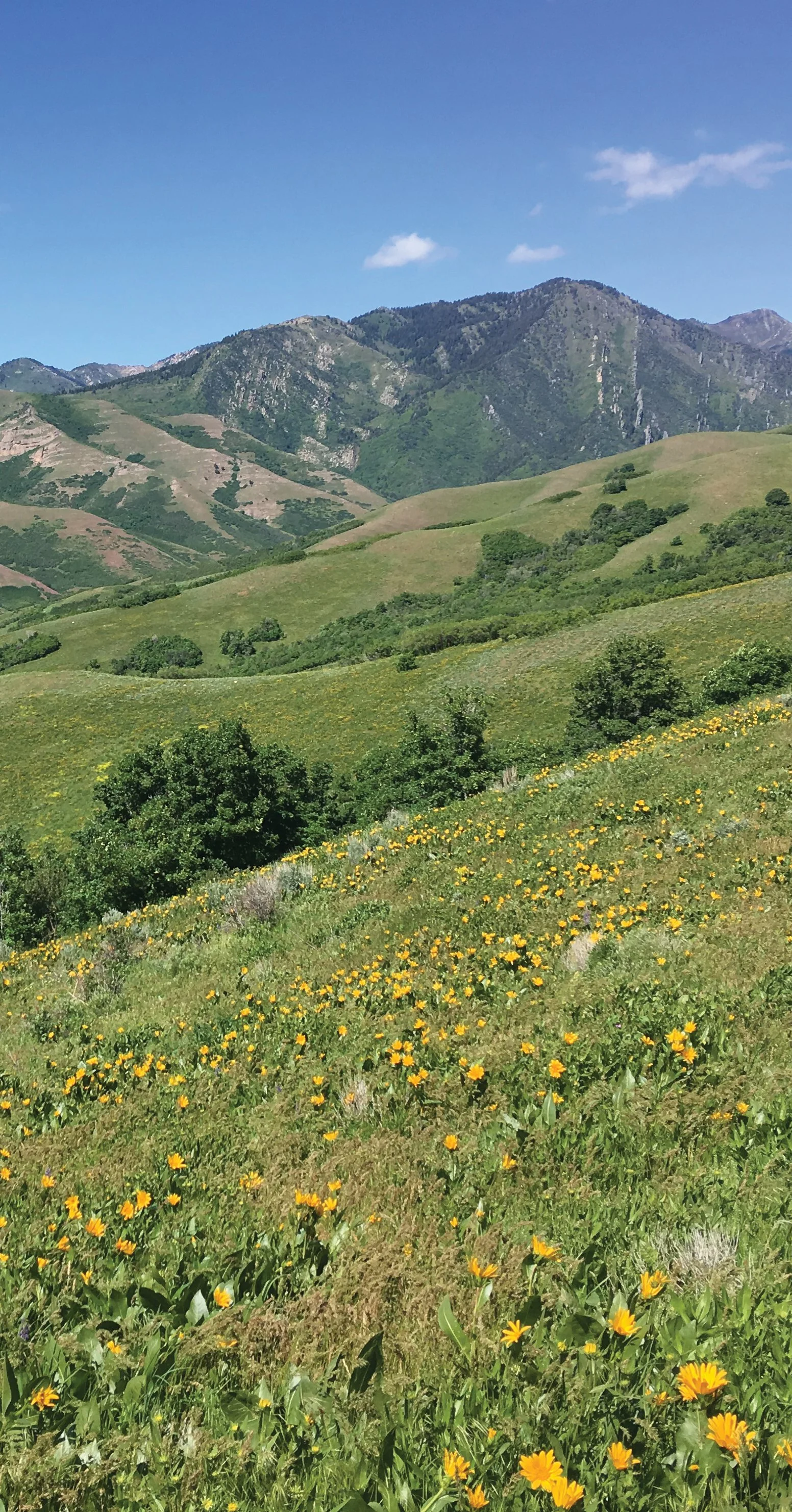
Save Our Foothills has prepared a comprehensive stewardship framework for the Salt Lake City Foothills—our local wilderness. Having historically provided essential resources such as water, wood, stone, and wildlife habitat, the foothills also provide opportunities for recreation, relaxation and reflection. Increasingly, the foothills are being recognized as a unique and irreplaceable public treasure for our expanding and diversifying community.
There is a growing awareness that the foothills themselves continue to be profoundly impacted by human activities on the landscapes, presenting challenges for contemporary stewardship. Save Our Foothills has prepared a Land Use and Recreation Management Map to provide a framework that invites diverse recreation while sustainably protecting the ecologically complex natural lands. This creates a buffer between the bustling city and the more remote foothills ecosystems.
As part of our vision we have identified six distinct areas on our Land Use and Recreation Management Map, designating varying degrees of recreational access and habitat protection. Recreational opportunities for all user groups are concentrated near the urban/natural lands boundary, providing equitable access.
The framework ensures that recreational activities farther from the urban-foothills boundary will be less intrusive. In short, by allowing for respectful and responsible recreation in the Foothills today, this stewardship vision safeguards ecosystem integrity into the future.
As part of our stewardship vision we have defined six distinct area types within the Salt Lake City Foothills. These include:
Multi- or Shared-Use Areas
Pedestrian Only Areas
Mountain Bike Use Only Areas
Habitat Conservation Areas
Currently/Permanently Protected Area
a.City Creek Canyon Watershed Management Area and Natural Preserve
b. Red Butte Canyon Research Natural AreaEstablished Use/Alternative Use Areas
1. Multi- or Shared-Use: These areas welcome a wide spectrum of non-motorized vehicle use, including hiking, biking, dog walking, bird watching, horseback riding, picnicking, etc. Except where otherwise specified this includes all areas along the edge of the City downslope from the existing Bonneville Shoreline Trail (BST), which defines the uppermost extent of this area.
2. Pedestrian Only: Areas above the Bonneville Shoreline Trail are reserved for pedestrian use only except where otherwise specified.
Exceptions include:
a. The 19th Avenue downhill mountain bike trail
b. City Creek Peak road
c. Lost Lad downhill mountain bike trail
3. Mountain Bike Use Only: This area includes already established dedicated mountain bike parks and trails. While several of these parks and trails continue to be user built, the altering or changing of any trails henceforth should be under the auspices of Salt Lake City Public Lands.
4. Habitat Conservation Areas: Habitat Conservation Areas (HCA) sustain greater biodiversity by providing a higher degree of protection for wildlife habitats and corridors, restricting habitat fragmentation, and minimizing impacts of human activities. Particularly sensitive or relatively undisturbed areas warrant prioritizing HCA protections.
5. Currently Protected Areas: These areas have established environmental and recreational regulations in place to protect ecosystem integrity.
a. City Creek Canyon Watershed Management Area and Natural Preserve: This area is a vital Salt Lake City watershed and is managed to protect water access, water quality, and water delivery systems. This area should be studied to determine if it is an “Ancestral Forest Garden” of the Ute People, and co-managed as such if appropriate. (An Ancestral Forest Garden is a food production and land management system based on the traditional ecological knowledge of Indigenous and historical cultures.)
b. Red Butte Canyon Research Natural Area: This area is closed to public access to protect and study the biodiversity of this ecosystem.
6. Established or Alternative Use: This category includes existing structures, parks, or protected areas (UMNH, Red Butte Garden, This Is The Place, Bonneville Shoreline Preserve) that are currently adjacent to or on the Foothills natural lands, or areas warranting specialized designation such as nature trails.
Additional considerations for land use management and stewardship include:
Indigenous Perspective/Input
Dog Walking Opportunities/Management
Adaptive Recreation/ADA Accommodation
Old Growth Forest Conservation/Protection
Educational Opportunities/18th Ave Meadow Nature Trail
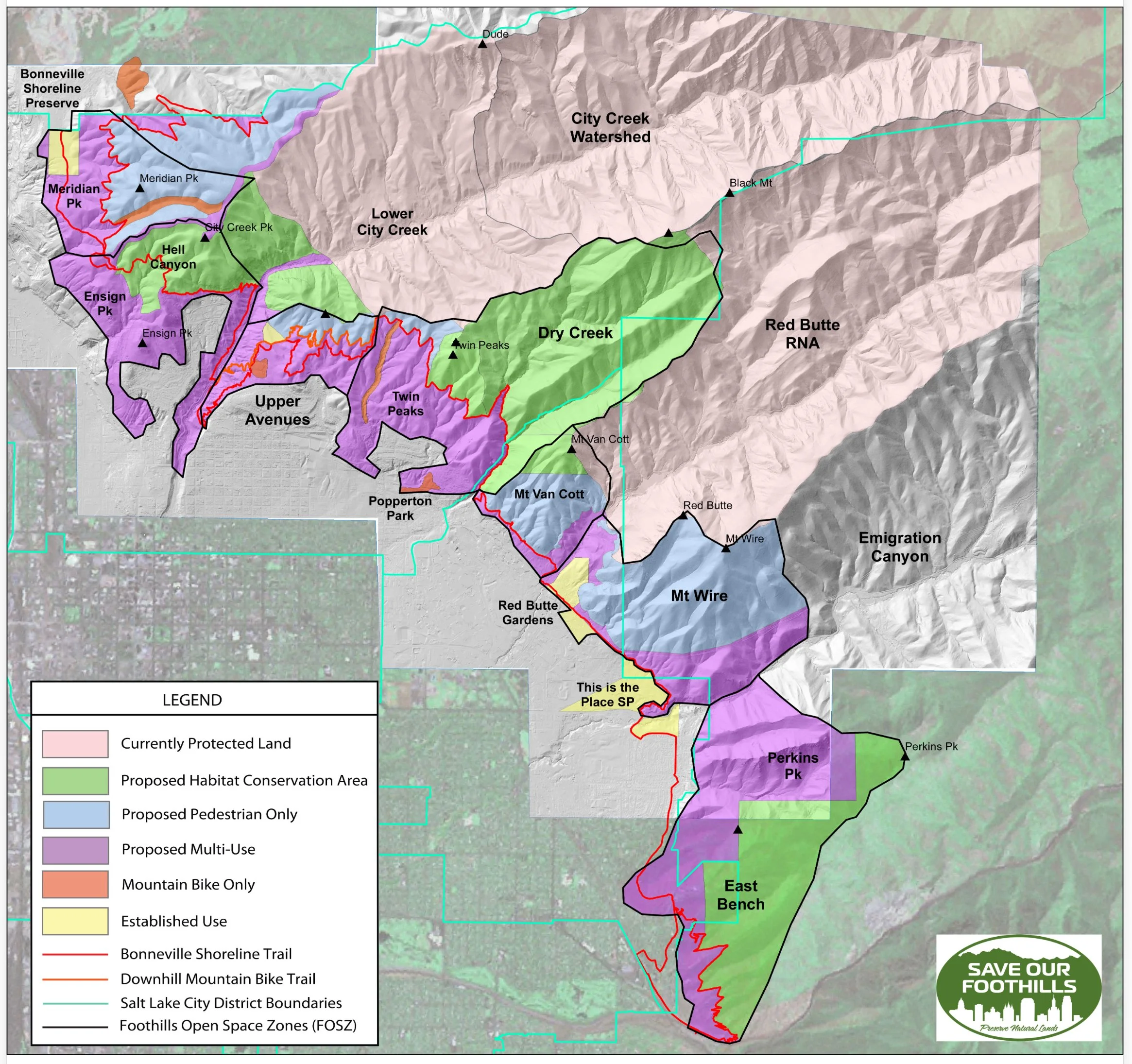
Figure 1. Proposed Land Use and Recreation Management Map for the Salt Lake City Foothills
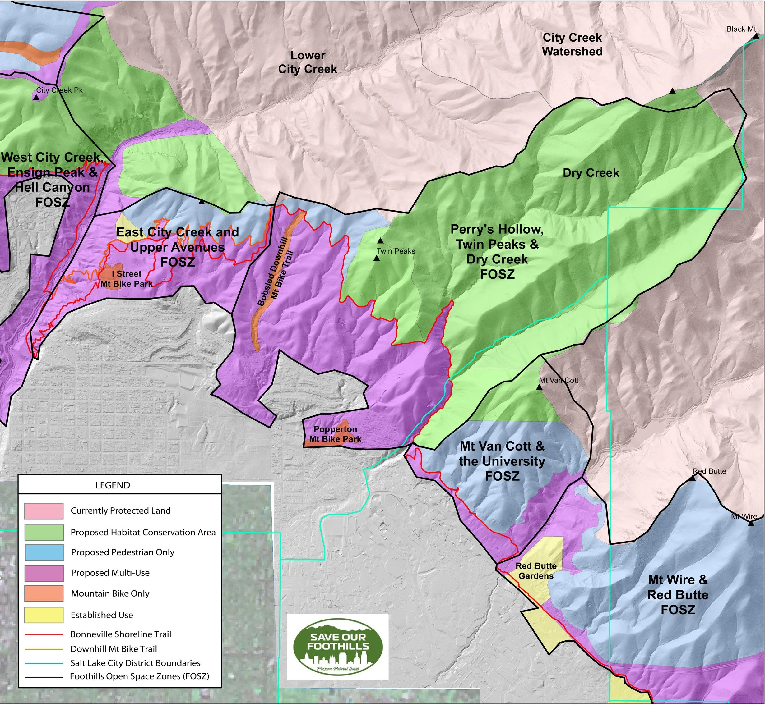
Figure 2. Detail of Proposed Land Use and Recreation Management Map for the Salt Lake City Foothills showing the East City Creek & Upper Avenues FOSZ, and the Perry’s Hollow, Twin Peaks & Dry Creek FOSZ.
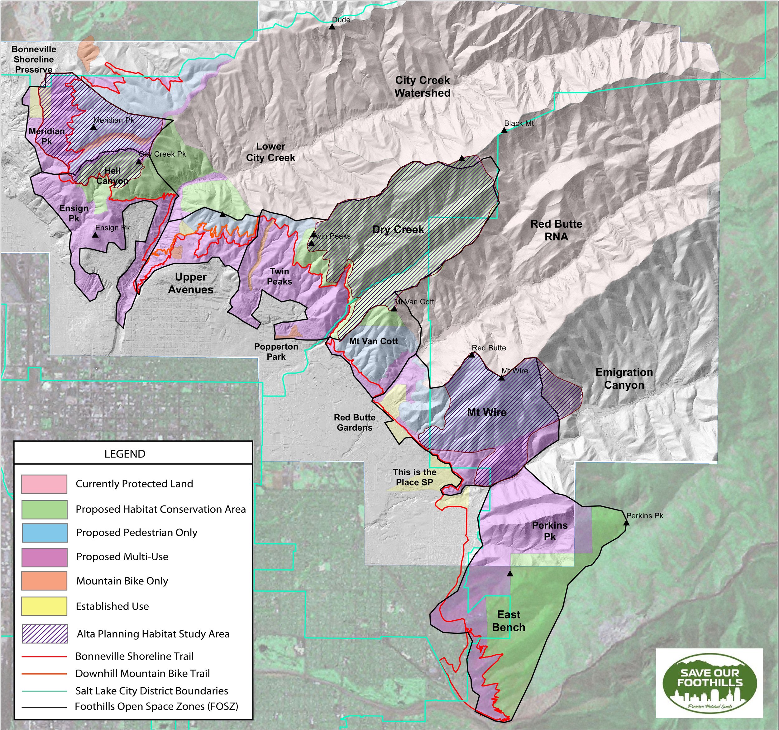
Figure 3. Proposed Land Use and Recreation Management Map for the Salt Lake City Foothills showing “Habitat Study Areas” defined by Alta Planning and Design as part of the 2020 Salt Lake City Foothills Trail Plan. Note the overlap between the “Habitat Study Areas” defined by Alta Planning and Design, and the “Proposed Habitat Conservation” and “Proposed Pedestrian Only” areas identified by Save Our Foothills.
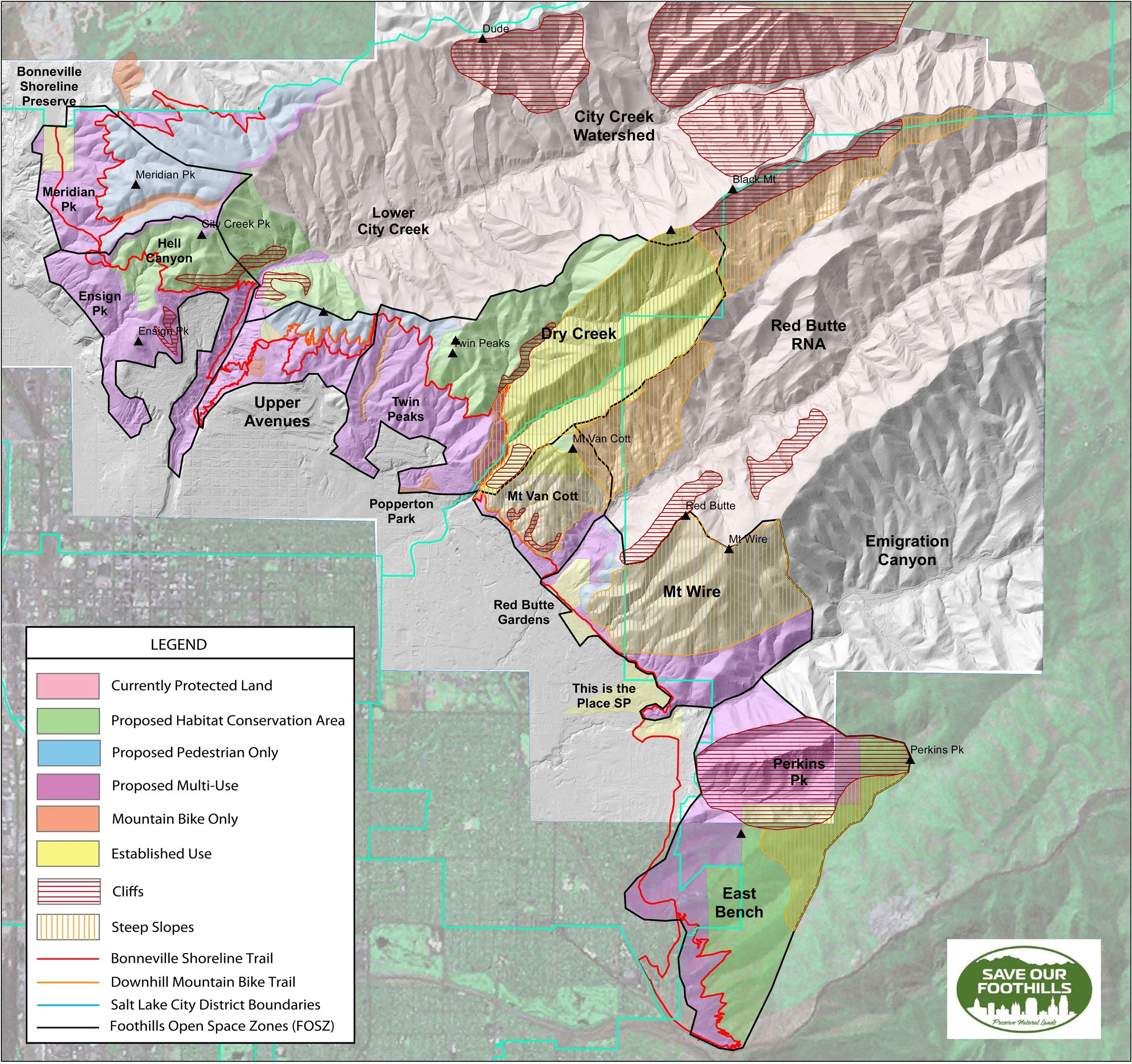
Figure 4. Proposed Land Use and Recreation Management Map for the Salt Lake City Foothills showing cliff areas, where trails cannot be built, and steep slopes where trails would be difficult to build and/or unsustainable.
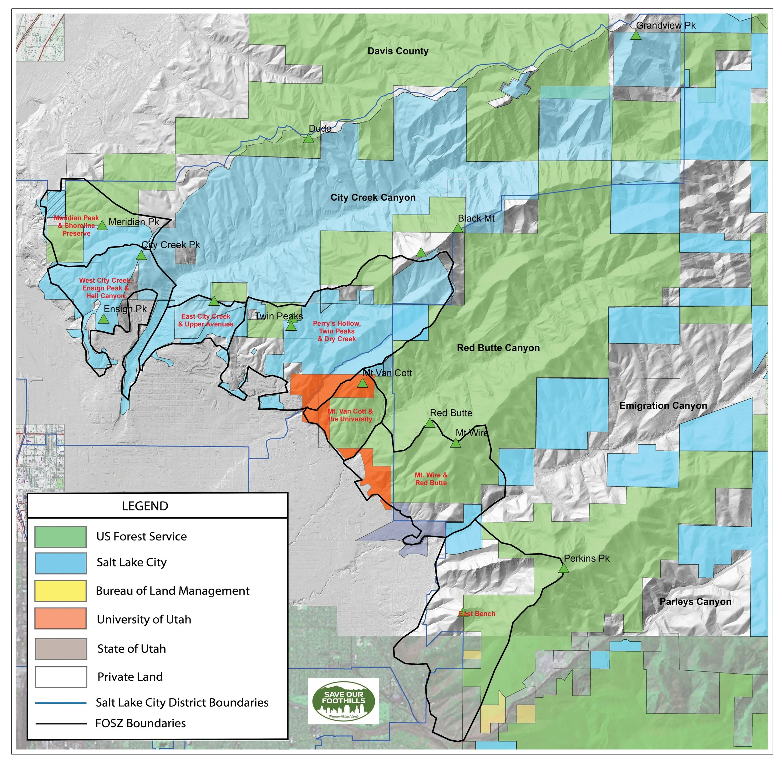
Figure 5. Land Ownership Map for the Salt Lake City Foothills with Foothill Open Space Zones (FOSZ)